Mexico City has been slowly sinking for decades, and a new eye in the sky is tracking the phenomenon with remarkable precision. The NISAR satellite—a joint NASA-ISRO mission—captured detailed images of land subsidence across the metropolis from late 2025 to early 2026. This Q&A unpacks what the data shows, why the ground is dropping, and how the spacecraft's radar technology makes such measurements possible.
1. What is NISAR and what did it capture?
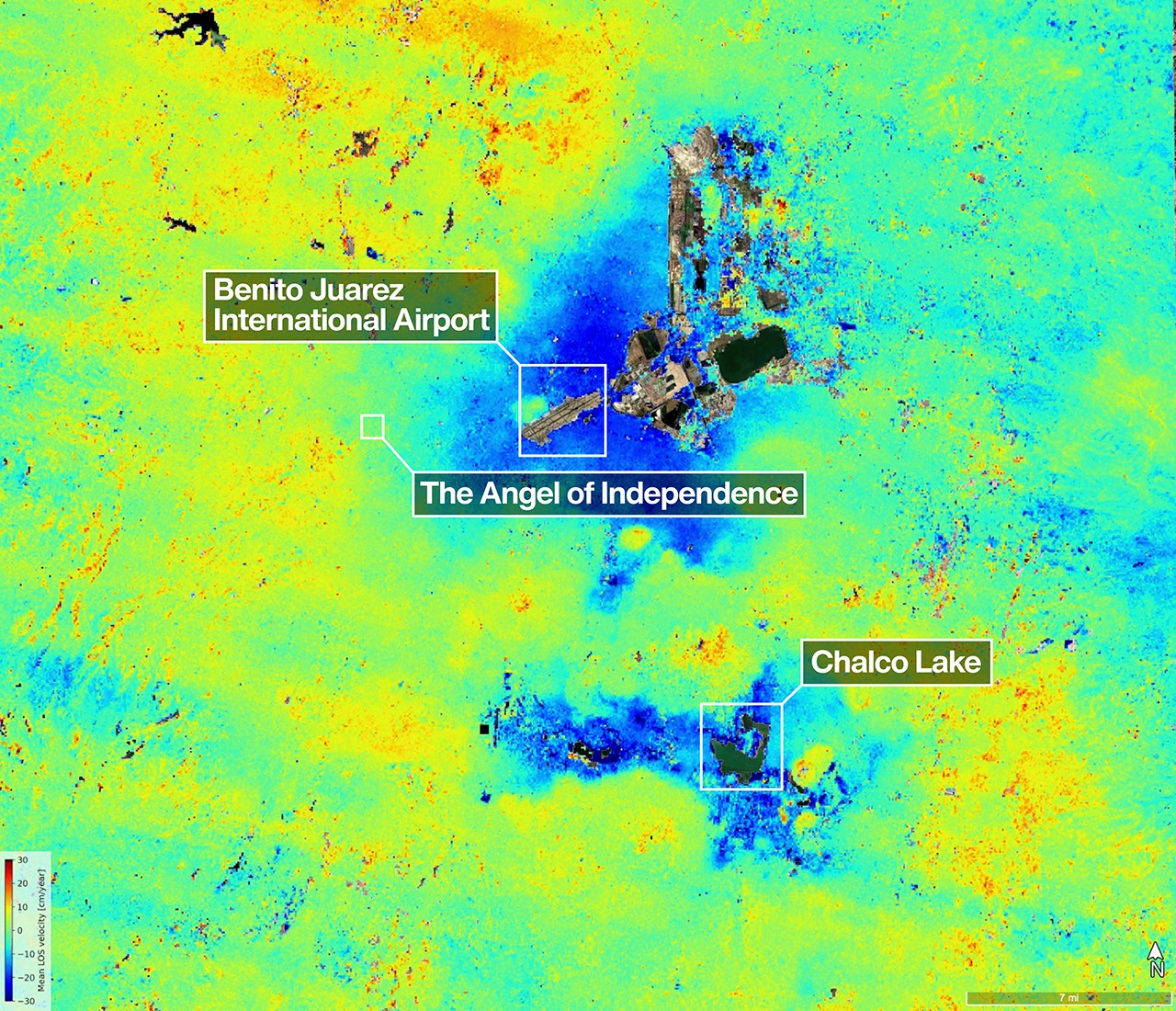
NISAR stands for NASA-ISRO Synthetic Aperture Radar mission, a collaboration between the U.S. space agency and the Indian Space Research Organisation. It uses two radar instruments—an L-band and an S-band—to monitor Earth's surface changes. Between October 25, 2025, and January 17, 2026, NISAR captured a detailed map of land subsidence in Mexico City. The dark blue areas on the image indicate ground sinking by more than half an inch (over 2 centimeters) per month. The yellow and red patches are residual noise that will decrease as more data is collected. This early imagery confirms NISAR is performing as expected in its first year of operation.
2. Why is Mexico City sinking so fast?
The primary culprit is groundwater pumping. Mexico City was built on the dry, ancient lakebed of Lake Texcoco, which consists of soft, compressible clay. As residents and industries extract water from the aquifers beneath the city, the empty spaces left behind cause the lakebed sediments to compact and settle. This compaction leads to the ground sinking—a process known as subsidence. The rate can exceed 2 centimeters per month in some areas, making it one of the fastest-sinking cities on Earth.
3. Which landmarks and lakes appear in the NISAR image?
Several notable features stand out. The Angel of Independence, a 100-foot-tall monument on Paseo de la Reforma, has had 14 steps added to its base over the years as the ground around it gradually dropped. Also visible are two marshy ecosystems tied to the region's history: Nabor Carrillo, an artificial lake built over the former Lake Texcoco, and Chalco Lake, a wetland south of the airport. Chalco Lake was once a major body of water, drained over centuries to reduce flooding. It was also a primary habitat of the endangered Mexican Axolotl salamander.
4. How does NISAR measure ground sinking?
NISAR uses synthetic aperture radar (SAR) to send microwave pulses toward Earth and record the reflections. The L-band radar (9-inch or 24-centimeter wavelength) can penetrate dense vegetation like forest canopies, making it ideal for urban areas as well. By comparing radar images taken weeks apart, the satellite detects tiny changes in surface height—down to fractions of an inch. The S-band radar, provided by ISRO, complements L-band data. This technique, called interferometric SAR (InSAR), reveals how much the ground has moved between visits.

5. What does this mean for future subsidence monitoring?
NISAR's high-resolution, frequent observations will help scientists track subsidence trends over time, identify hotspots, and inform water management policies. The current images are just a snapshot; as the mission collects more data, the noise (yellow/red areas) will decrease, yielding even cleaner maps. This capability is critical for cities like Mexico City, where subsidence damages infrastructure, increases flood risk, and strains water resources. The NASA-ISRO partnership also demonstrates how international collaboration can advance our understanding of Earth's dynamic surface.
6. Are other cities experiencing similar subsidence?
Yes, many coastal and inland cities worldwide face subsidence, often due to groundwater extraction, oil and gas drilling, or natural compaction. Examples include Jakarta, Shanghai, Venice, and parts of California's Central Valley. NISAR's global coverage will allow scientists to compare subsidence rates and causes across different regions. The mission's data can also help assess how sea-level rise and subsidence combine to amplify flood threats in coastal areas. By providing consistent, high-quality radar imagery, NISAR will become a key tool for monitoring these hazards worldwide.